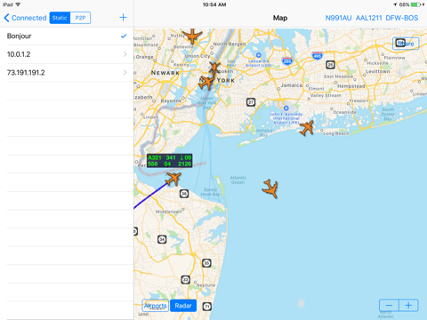
RealADSB app is intended for stationary observers of local air traffic. It can consume traffic feed generated by adsb_hub or adsb_hub3 server application. With some limitations traffic feed in SBS-1 BaseStation format (port 30003) is also supported. For example Stratux ADS-B device or ADSBx feeder can produce such feed. Another option to get traffic feed is to use Airplanes.live API integration. That could be a good way to start using app because such option doesnt require additional hardware.
You can setup traffic feed yourself or use one of the public feeds covering Germany, UK and New York. adsb_hub server application is using Java runtime and can run on PC, Mac or Raspberry Pi. It can work on top of FlightAware, FR24 feeders or generate feed using cheap USB adapter and external antenna. For more information please check our web site http://www.realadsb.com
Inside mobile app commercial, private and military aircrafts are shown on map or in scrollable list sorted by distance from reference point. It can be your current location or airport defined by ICAO code such as LFPG. When ICAO code entered special button provides access to METAR and aircrafts below transition altitude will have altitude adjusted using barometric pressure of the airport. There is a way to search/filter aircrafts by tail number, callsign, type, altitude in both list and on map. Additionally 2 layers with airports and weather are available on map.
For each airframe following basic parameters shown:
* Speed, Altitude, Heading, Rate of climb/descend, Squawk
and for most of them there is additional information:
* Tail number, Callsign, ICAO type, Origin/Destination, Photo
If information about tail number or type of aircraft is missing you can easily add it right inside the app. This change will be automatically shared across all devices that using same iCloud account.
Other features:
* Quick access to online resources including FlightAware, Google Flights, LiveATC etc.
* Push notifications for special squawks 7500/7600/7700
* Imperial or metric units
* 3 types of map: standard, satellite and hybrid
* Sharing of map with aircrafts using standard iOS Sharing Panel
* Barometric pressure and altitude measured by mobile device conveniently shown at the bottom of main menu


